A magnitude 6.7 earthquake struck Sulawesi Island in Indonesia on Tuesday, June 16, 2026, leaving at least one person dead [1, 4].
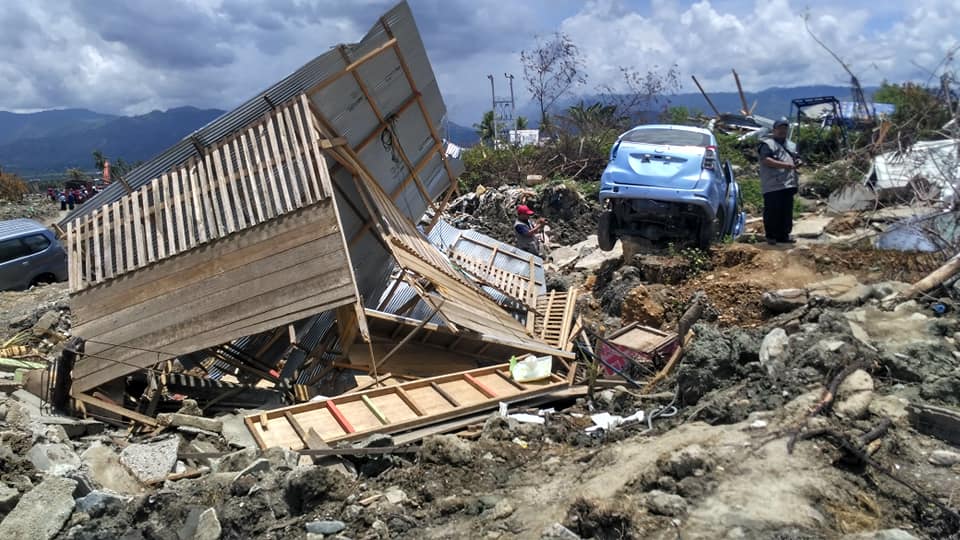
The event underscores the persistent vulnerability of the region to seismic activity, where shallow quakes can cause significant structural damage and loss of life.
Indonesia's national geophysics agency, BMKG, said the quake's epicentre was located approximately 42 km (26.1 mi) southeast of the town of Palu [2]. The tremor occurred at a depth of 10 km [3], which contributed to the intensity of the shaking felt on the surface.
Emergency responders said that at least eight people were injured in the aftermath [5]. While some initial reports focused on injuries, later updates confirmed at least one fatality [4]. Local authorities monitored the area for aftershocks following the primary tremor.
Experts said the earthquake was due to tectonic activity along the Pacific Ring of Fire [6]. This region is known for frequent volcanic eruptions and seismic events due to the movement of several tectonic plates.
The shallow nature of the quake, occurring only 10 km below the surface [3], often increases the risk of landslides and building collapses in densely populated coastal areas like Palu. Local agencies continue to assess the full extent of the damage to infrastructure and residential homes.
“At least one person died and eight others were injured”
The occurrence of a shallow, high-magnitude earthquake near Palu highlights the ongoing geological instability of Sulawesi. Because the epicentre was only 10 km deep, the energy release was more concentrated at the surface, increasing the potential for catastrophic failure of non-seismic-resistant structures in the region.

'%2F%3E%0A%20%20%20%20%3Crect%20width%3D'1600'%20height%3D'900'%20fill%3D'url(%23v)'%2F%3E%0A%20%20%20%20%3Cg%20opacity%3D'0.08'%20fill%3D'%23ffffff'%3E%0A%20%20%20%20%20%20%3Ccircle%20cx%3D'1420'%20cy%3D'180'%20r%3D'220'%2F%3E%0A%20%20%20%20%20%20%3Ccircle%20cx%3D'1500'%20cy%3D'760'%20r%3D'120'%2F%3E%0A%20%20%20%20%3C%2Fg%3E%0A%20%20%20%20%3Cline%20x1%3D'80'%20y1%3D'172'%20x2%3D'220'%20y2%3D'172'%20stroke%3D'%23ffffff'%20stroke-width%3D'3'%20stroke-opacity%3D'0.6'%2F%3E%0A%20%20%20%20%3Ctext%20x%3D'80'%20y%3D'140'%20font-family%3D'Inter%2C%20-apple-system%2C%20Helvetica%2C%20sans-serif'%20font-weight%3D'700'%20font-size%3D'28'%20fill%3D'%23ffffff'%20letter-spacing%3D'6'%3EHANNA%20%C2%B7%20NEWS%3C%2Ftext%3E%0A%20%20%20%20%3Ctext%20x%3D'80'%20y%3D'230'%20font-family%3D'Inter%2C%20-apple-system%2C%20Helvetica%2C%20sans-serif'%20font-weight%3D'600'%20font-size%3D'40'%20fill%3D'%23ffffffb3'%20letter-spacing%3D'4'%3EWORLD%3C%2Ftext%3E%0A%20%20%20%20%3Ctext%20x%3D'80'%20y%3D'622'%20font-family%3D'Playfair%20Display%2C%20Georgia%2C%20serif'%20font-weight%3D'800'%20font-size%3D'86'%20fill%3D'%23ffffff'%20letter-spacing%3D'-1'%3ERemote%20Work%20Linked%20to%20Mental%3C%2Ftext%3E%3Ctext%20x%3D'80'%20y%3D'721'%20font-family%3D'Playfair%20Display%2C%20Georgia%2C%20serif'%20font-weight%3D'800'%20font-size%3D'86'%20fill%3D'%23ffffff'%20letter-spacing%3D'-1'%3EHealth%20Decline%20for%20Those%3C%2Ftext%3E%3Ctext%20x%3D'80'%20y%3D'820'%20font-family%3D'Playfair%20Display%2C%20Georgia%2C%20serif'%20font-weight%3D'800'%20font-size%3D'86'%20fill%3D'%23ffffff'%20letter-spacing%3D'-1'%3ELiving%20Alone%3C%2Ftext%3E%0A%20%20%20%20%3Ctext%20x%3D'80'%20y%3D'870'%20font-family%3D'Inter%2C%20-apple-system%2C%20Helvetica%2C%20sans-serif'%20font-weight%3D'500'%20font-size%3D'22'%20fill%3D'%23ffffff66'%20letter-spacing%3D'2'%3Enews.hanna-ai.com%3C%2Ftext%3E%0A%20%20%3C%2Fsvg%3E)
